


pont l'enfer la Pierre saint Martin

taguette
User
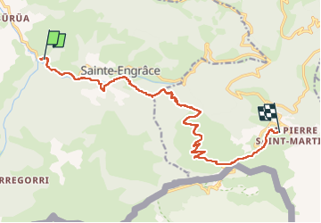

Length
15.5 km

Max alt
1784 m

Uphill gradient
1370 m
Km-Effort
30 km

Min alt
477 m

Downhill gradient
195 m
Boucle
No
Creation date :
2024-08-02 05:54:37.605
Updated on :
2024-08-02 12:22:51.351
6h27
Difficulty : Very difficult

FREE GPS app for hiking
 SityTrail
IGN / Geographical institutes
SityTrail Plus
The world is yours!
About
Trail Walking of 15.5 km to be discovered at New Aquitaine, Pyrénées-Atlantiques, Sainte-Engrâce. This trail is proposed by taguette.
Positioning
Country:
France
Region :
New Aquitaine
Department/Province :
Pyrénées-Atlantiques
Municipality :
Sainte-Engrâce
Location:
Unknown
Start:(Dec)
Start:(UTM)
676039 ; 4762954 (30T) N.
Comments