


col echelle

BELLETGE
User

Length
42 km

Max alt
1790 m

Uphill gradient
739 m
Km-Effort
52 km

Min alt
1364 m

Downhill gradient
739 m
Boucle
Yes
Creation date :
2024-08-05 07:46:00.857
Updated on :
2024-08-05 10:49:55.316
2h20
Difficulty : Easy

FREE GPS app for hiking
 SityTrail
IGN / Geographical institutes
SityTrail Plus
The world is yours!
About
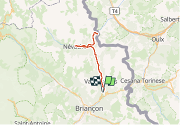
Trail Road bike of 42 km to be discovered at Provence-Alpes-Côte d'Azur, Hautes-Alpes, Montgenèvre. This trail is proposed by BELLETGE.
Positioning
Country:
France
Region :
Provence-Alpes-Côte d'Azur
Department/Province :
Hautes-Alpes
Municipality :
Montgenèvre
Location:
Unknown
Start:(Dec)
Start:(UTM)
317025 ; 4977717 (32T) N.
Comments