


test boucle cyclo collonges turenne

sdroneau
User
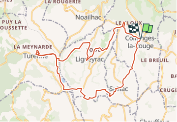

Length
22 km

Max alt
330 m

Uphill gradient
589 m
Km-Effort
29 km

Min alt
142 m

Downhill gradient
589 m
Boucle
Yes
Creation date :
2024-08-08 09:40:28.362
Updated on :
2024-08-08 09:41:52.995
2h30
Difficulty : Very easy

FREE GPS app for hiking
 SityTrail
IGN / Geographical institutes
SityTrail Plus
The world is yours!
About
Trail Bicycle tourism of 22 km to be discovered at New Aquitaine, Corrèze, Collonges-la-Rouge. This trail is proposed by sdroneau.
Positioning
Country:
France
Region :
New Aquitaine
Department/Province :
Corrèze
Municipality :
Collonges-la-Rouge
Location:
Unknown
Start:(Dec)
Start:(UTM)
394123 ; 4990687 (31T) N.
Comments