


Estau refuge d'Ayous

taguette
User
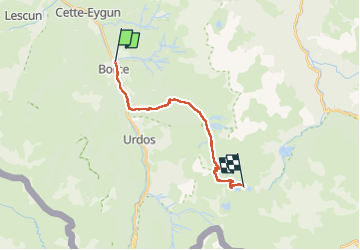

Length
16.5 km

Max alt
2183 m

Uphill gradient
1690 m
Km-Effort
35 km

Min alt
594 m

Downhill gradient
374 m
Boucle
No
Creation date :
2024-08-06 05:25:33.73
Updated on :
2024-08-08 15:57:42.034
8h03
Difficulty : Very difficult

FREE GPS app for hiking
 SityTrail
IGN / Geographical institutes
SityTrail Plus
The world is yours!
About
Trail Walking of 16.5 km to be discovered at New Aquitaine, Pyrénées-Atlantiques, Etsaut. This trail is proposed by taguette.
Positioning
Country:
France
Region :
New Aquitaine
Department/Province :
Pyrénées-Atlantiques
Municipality :
Etsaut
Location:
Unknown
Start:(Dec)
Start:(UTM)
698284 ; 4753942 (30T) N.
Comments