


Gabas

taguette
User
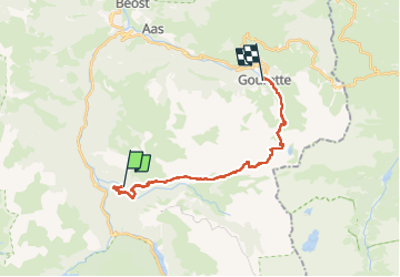

Length
21 km

Max alt
2477 m

Uphill gradient
1661 m
Km-Effort
42 km

Min alt
969 m

Downhill gradient
1273 m
Boucle
No
Creation date :
2024-08-08 05:32:39.119
Updated on :
2024-08-08 15:57:46.129
10h13
Difficulty : Very difficult

FREE GPS app for hiking
 SityTrail
IGN / Geographical institutes
SityTrail Plus
The world is yours!
About
Trail Walking of 21 km to be discovered at New Aquitaine, Pyrénées-Atlantiques, Laruns. This trail is proposed by taguette.
Positioning
Country:
France
Region :
New Aquitaine
Department/Province :
Pyrénées-Atlantiques
Municipality :
Laruns
Location:
Unknown
Start:(Dec)
Start:(UTM)
710638 ; 4753984 (30T) N.
Comments