


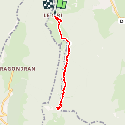
Croix du Nivolet

mhetpierre
User

Length
7.4 km

Max alt
1544 m

Uphill gradient
247 m
Km-Effort
10.6 km

Min alt
1411 m

Downhill gradient
248 m
Boucle
Yes
Creation date :
2018-08-18 15:30:27.805
Updated on :
2018-08-18 15:30:27.805
3h16
Difficulty : Easy

FREE GPS app for hiking
 SityTrail
IGN / Geographical institutes
SityTrail Plus
The world is yours!
About
Trail Walking of 7.4 km to be discovered at Auvergne-Rhône-Alpes, Savoy, Les Déserts. This trail is proposed by mhetpierre.
Positioning
Country:
France
Region :
Auvergne-Rhône-Alpes
Department/Province :
Savoy
Municipality :
Les Déserts
Location:
Unknown
Start:(Dec)
Start:(UTM)
731064 ; 5057936 (31T) N.
Comments