


rea mt genevre

JPS73
User
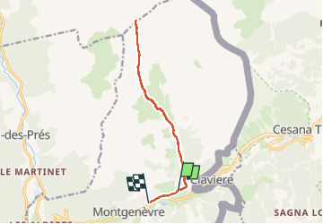

Length
13.3 km

Max alt
2587 m

Uphill gradient
723 m
Km-Effort
23 km

Min alt
1846 m

Downhill gradient
738 m
Boucle
No
Creation date :
2024-08-13 06:18:31.058
Updated on :
2024-08-13 12:36:16.893
4h22
Difficulty : Very difficult

FREE GPS app for hiking
 SityTrail
IGN / Geographical institutes
SityTrail Plus
The world is yours!
About
Trail Walking of 13.3 km to be discovered at Provence-Alpes-Côte d'Azur, Hautes-Alpes, Montgenèvre. This trail is proposed by JPS73.
Positioning
Country:
France
Region :
Provence-Alpes-Côte d'Azur
Department/Province :
Hautes-Alpes
Municipality :
Montgenèvre
Location:
Unknown
Start:(Dec)
Start:(UTM)
321455 ; 4978286 (32T) N.
Comments