


urbes

danif
User
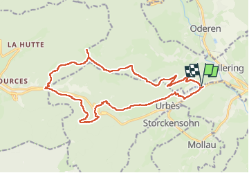

Length
20 km

Max alt
1188 m

Uphill gradient
896 m
Km-Effort
32 km

Min alt
441 m

Downhill gradient
894 m
Boucle
Yes
Creation date :
2024-08-13 07:08:17.601
Updated on :
2024-08-13 14:44:29.337
7h34
Difficulty : Very difficult

FREE GPS app for hiking
 SityTrail
IGN / Geographical institutes
SityTrail Plus
The world is yours!
About
Trail Walking of 20 km to be discovered at Grand Est, Haut-Rhin, Fellering. This trail is proposed by danif.
Positioning
Country:
France
Region :
Grand Est
Department/Province :
Haut-Rhin
Municipality :
Fellering
Location:
Unknown
Start:(Dec)
Start:(UTM)
348529 ; 5306093 (32T) N.
Comments