


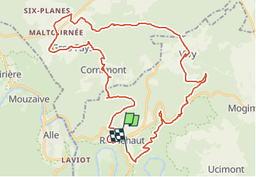
Rochehaut - Cornimont- Liresse 26 km 👍

DidierDHane
User

Length
24 km

Max alt
429 m

Uphill gradient
675 m
Km-Effort
33 km

Min alt
254 m

Downhill gradient
635 m
Boucle
No
Creation date :
2024-08-14 13:32:08.829
Updated on :
2024-08-14 15:45:31.673
2h12
Difficulty : Difficult

FREE GPS app for hiking
 SityTrail
IGN / Geographical institutes
SityTrail Plus
The world is yours!
About
Trail Mountain bike of 24 km to be discovered at Wallonia, Luxembourg, Bouillon. This trail is proposed by DidierDHane.
Description
VTT au départ de Rochehaut vers Cornimont, Vivy, Liresse, possibilité de descendre sur Poupehan et remonter par Frahan 👍 passages des ruisseaux évités 👍
Positioning
Country:
Belgium
Region :
Wallonia
Department/Province :
Luxembourg
Municipality :
Bouillon
Location:
Unknown
Start:(Dec)
Start:(UTM)
644297 ; 5522991 (31U) N.
Comments