


chamaloc but aiglette

Joel26400
User
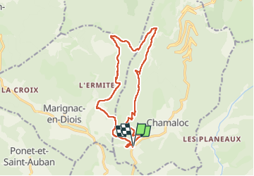

Length
16.6 km

Max alt
1544 m

Uphill gradient
1099 m
Km-Effort
31 km

Min alt
501 m

Downhill gradient
1099 m
Boucle
Yes
Creation date :
2024-08-04 06:33:12.621
Updated on :
2024-08-14 15:46:48.752
6h10
Difficulty : Very difficult

FREE GPS app for hiking
 SityTrail
IGN / Geographical institutes
SityTrail Plus
The world is yours!
About
Trail Walking of 16.6 km to be discovered at Auvergne-Rhône-Alpes, Drôme, Chamaloc. This trail is proposed by Joel26400.
Description
très belle rando
Positioning
Country:
France
Region :
Auvergne-Rhône-Alpes
Department/Province :
Drôme
Municipality :
Chamaloc
Location:
Unknown
Start:(Dec)
Start:(UTM)
687299 ; 4962420 (31T) N.
Comments