


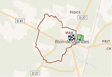
tuilerie, le carriou, le mont, lessègues, mâa - 7.7

hartmannpat
User

Length
7.5 km

Max alt
85 m

Uphill gradient
78 m
Km-Effort
8.6 km

Min alt
62 m

Downhill gradient
78 m
Boucle
Yes
Creation date :
2024-08-15 07:03:49.394
Updated on :
2024-08-16 05:48:36.831
1h56
Difficulty : Medium

FREE GPS app for hiking
 SityTrail
IGN / Geographical institutes
SityTrail Plus
The world is yours!
About
Trail Walking of 7.5 km to be discovered at New Aquitaine, Landes, Rion-des-Landes. This trail is proposed by hartmannpat.
Description
a vérifier entre le chemin après le champs de chez Castel, la portion qui mène à la fontaine
Positioning
Country:
France
Region :
New Aquitaine
Department/Province :
Landes
Municipality :
Rion-des-Landes
Location:
Rion-des-Landes
Start:(Dec)
Start:(UTM)
666924 ; 4866635 (30T) N.
Comments