


malaterre

Liebeaux
User
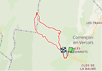

Length
8 km

Max alt
1314 m

Uphill gradient
207 m
Km-Effort
10.8 km

Min alt
1143 m

Downhill gradient
206 m
Boucle
Yes
Creation date :
2024-08-16 09:03:46.003
Updated on :
2024-08-16 12:02:54.044
2h58
Difficulty : Medium

FREE GPS app for hiking
 SityTrail
IGN / Geographical institutes
SityTrail Plus
The world is yours!
About
Trail Walking of 8 km to be discovered at Auvergne-Rhône-Alpes, Isère, Corrençon-en-Vercors. This trail is proposed by Liebeaux.
Positioning
Country:
France
Region :
Auvergne-Rhône-Alpes
Department/Province :
Isère
Municipality :
Corrençon-en-Vercors
Location:
Unknown
Start:(Dec)
Start:(UTM)
698361 ; 4988785 (31T) N.
Comments