


160824

rolandwin
User
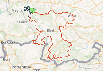

Length
108 km

Max alt
794 m

Uphill gradient
2032 m
Km-Effort
135 km

Min alt
298 m

Downhill gradient
2066 m
Boucle
No
Creation date :
2024-08-16 06:02:19.535
Updated on :
2024-08-16 15:21:10.169
9h17
Difficulty : Very difficult

FREE GPS app for hiking
 SityTrail
IGN / Geographical institutes
SityTrail Plus
The world is yours!
About
Trail Mountain bike of 108 km to be discovered at Grand Est, Haut-Rhin, Strueth. This trail is proposed by rolandwin.
Positioning
Country:
France
Region :
Grand Est
Department/Province :
Haut-Rhin
Municipality :
Strueth
Location:
Unknown
Start:(Dec)
Start:(UTM)
357971 ; 5271456 (32T) N.
Comments