


randonnée le chapeau de Napoléon

MICDURAND
User
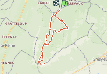

Length
17.5 km

Max alt
1818 m

Uphill gradient
1047 m
Km-Effort
31 km

Min alt
871 m

Downhill gradient
1048 m
Boucle
Yes
Creation date :
2024-08-13 06:26:50.356
Updated on :
2024-08-16 18:58:06.324
5h03
Difficulty : Medium

FREE GPS app for hiking
 SityTrail
IGN / Geographical institutes
SityTrail Plus
The world is yours!
About
Trail Walking of 17.5 km to be discovered at Auvergne-Rhône-Alpes, Savoy, École. This trail is proposed by MICDURAND.
Positioning
Country:
France
Region :
Auvergne-Rhône-Alpes
Department/Province :
Savoy
Municipality :
École
Location:
Unknown
Start:(Dec)
Start:(UTM)
282183 ; 5057747 (32T) N.
Comments