


musculdyG4

LouisROGER
User GUIDE
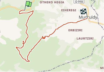

Length
9.4 km

Max alt
701 m

Uphill gradient
236 m
Km-Effort
13.5 km

Min alt
199 m

Downhill gradient
513 m
Boucle
No
Creation date :
2024-08-16 08:04:48.276
Updated on :
2024-08-18 13:08:45.394
5h40
Difficulty : Difficult

FREE GPS app for hiking
 SityTrail
IGN / Geographical institutes
SityTrail Plus
The world is yours!
About
Trail Walking of 9.4 km to be discovered at New Aquitaine, Pyrénées-Atlantiques, Musculdy. This trail is proposed by LouisROGER.
Positioning
Country:
France
Region :
New Aquitaine
Department/Province :
Pyrénées-Atlantiques
Municipality :
Musculdy
Location:
Unknown
Start:(Dec)
Start:(UTM)
662170 ; 4784899 (30T) N.
Comments