


Roseland > rocher des vents > crête des Gittes > Croix du Bonhomme

catduv
User
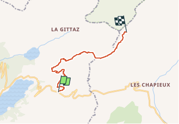

Length
9.6 km

Max alt
2515 m

Uphill gradient
991 m
Km-Effort
21 km

Min alt
1811 m

Downhill gradient
367 m
Boucle
No
Creation date :
2024-08-20 06:38:43.952
Updated on :
2024-08-21 16:12:46.71
3h34
Difficulty : Difficult

FREE GPS app for hiking
 SityTrail
IGN / Geographical institutes
SityTrail Plus
The world is yours!
About
Trail Walking of 9.6 km to be discovered at Auvergne-Rhône-Alpes, Savoy, Beaufort. This trail is proposed by catduv.
Positioning
Country:
France
Region :
Auvergne-Rhône-Alpes
Department/Province :
Savoy
Municipality :
Beaufort
Location:
Unknown
Start:(Dec)
Start:(UTM)
318618 ; 5062600 (32T) N.
Comments