Trail Running Boulogne-Billancourt - Entrainement Urban Trail GPSO - Photo

Entrainement Urban Trail GPSO

 lakeo92
lakeo92

User

© OpenStreetMap contributors
Length
Length
42 km
Max alt
Max alt
188 m
Uphill gradient
Uphill gradient
863 m
Km-Effort
Km-Effort  
54 km
Min alt
Min alt
12 m
Downhill gradient
Downhill gradient
860 m
Boucle
Boucle
Yes
Creation date :
2015-09-16 00:00:00.0
Updated on :
2015-09-16 00:00:00.0

(0 Reviews)

Running
Running
5h00
Difficulty : Difficult

Scan this QR Code to open this trail in the SityTrail application

FREE GPS app for hiking

Logo SityTrail SityTrail

IGN / Geographical institutes

Download SityTrail from the App Store Download SityTrail from Google Play

Logo SityTrail SityTrail World

The world is yours!

Download SityTrail from the App Store Download SityTrail from Google Play Download SityTrail on Huawei AppGallery

About

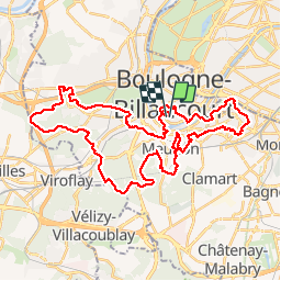
Trail Running of 42 km to be discovered at Ile-de-France, Hauts-de-Seine, Boulogne-Billancourt. This trail is proposed by lakeo92.

Description

Parcours d'entrainement sur les communes du Grand Paris Seine Ouest 42,195 km - 811m D  - environ 5h. Parcours très physique (escaliers, raidillons, petites sentes bien cachées, relances...etc...)Possibilité de le faire en 2 parties en coupant à l'Observatoire de Meudon.

Elevation profile

Positioning

Country:
France
Region :
Ile-de-France
Department/Province :
Hauts-de-Seine
Municipality :
Boulogne-Billancourt
Location:
Unknown
Start:(UTM)
444080 ; 5408385 (31U) N.

Trails nearby

Trail Walking Chaville - Le Sentier des 7 étangs - Photo
Walking
tracegps

Walking

Difficult
(5)
Chaville, Ile-de-France, Hauts-de-Seine, France
23 km | 31 km-effort
5h 0min
Yes
Trail Walking Paris - DP75-13 De Vaugirard à Sèvres-Babylone - Photo
Walking
clalaur

Walking

Easy
(1)
Paris, Ile-de-France, Paris, France
4.4 km | 5 km-effort
1h 8min
No
Trail Walking Paris - DP75-11 De Boulainvilliers à pont du Garigliano - Photo
Walking
clalaur

Walking

Easy
(1)
Paris, Ile-de-France, Paris, France
4.7 km | 5.4 km-effort
1h 13min
No
Trail Cycle Paris - Paris au bord de Seine - Photo
Cycle
aurel911

Cycle

Very easy
(1)
Paris, Ile-de-France, Paris, France
11.4 km | 14.2 km-effort
46min
No
Trail Walking Paris - 75-05-Paris les Boulevards 13km-625-799- - Photo
Walking
rvs147

Walking

Easy
(1)
Paris, Ile-de-France, Paris, France
12.7 km | 15.4 km-effort
3h 12min
Yes
Trail Walking Paris - 75-04-Paris les Ponts 13km-493-55- - Photo
Walking
rvs147

Walking

Easy
(1)
Paris, Ile-de-France, Paris, France
13.1 km | 16.3 km-effort
3h 22min
No
Trail Walking Chaville - Sentier des deux Forêts - Meudon et Verrières - Photo
Walking
tracegps

Walking

Difficult
(2)
Chaville, Ile-de-France, Hauts-de-Seine, France
23 km | 29 km-effort
5h 0min
Yes
Trail Walking Boulogne-Billancourt - Parc de St Cloud et forêt de Fausses Reposes - Photo
Walking
tracegps

Walking

Medium
(1)
Boulogne-Billancourt, Ile-de-France, Hauts-de-Seine, France
18.2 km | 23 km-effort
4h 30min
No
Trail Walking Fontenay-aux-Roses -  Rando des 3 Parcs ! (des Gares RER) - Photo
Walking
dmj41

Walking

Very difficult
(2)
Fontenay-aux-Roses, Ile-de-France, Hauts-de-Seine, France
15.9 km | 19.5 km-effort
4h 26min
No


Close
My subscriptions