


Col et Pic de GLEIZE

JEANJOSY
User
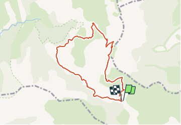

Length
8.6 km

Max alt
2142 m

Uphill gradient
601 m
Km-Effort
16.6 km

Min alt
1681 m

Downhill gradient
593 m
Boucle
Yes
Creation date :
2015-05-06 00:00:00.0
Updated on :
2015-05-06 00:00:00.0
3h39
Difficulty : Unknown

FREE GPS app for hiking
 SityTrail
IGN / Geographical institutes
SityTrail Plus
The world is yours!
About
Trail Walking of 8.6 km to be discovered at Provence-Alpes-Côte d'Azur, Hautes-Alpes, Gap. This trail is proposed by JEANJOSY.
Positioning
Country:
France
Region :
Provence-Alpes-Côte d'Azur
Department/Province :
Hautes-Alpes
Municipality :
Gap
Location:
Gap
Start:(Dec)
Start:(UTM)
265860 ; 4945287 (32T) N.
Comments
super ballade fait en sens inverse le20 sept. 2017 par gilou 440