


tulle

chanac les mines
User
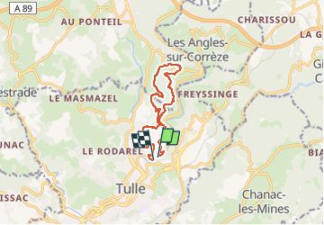

Length
10.3 km

Max alt
417 m

Uphill gradient
311 m
Km-Effort
14.4 km

Min alt
217 m

Downhill gradient
307 m
Boucle
Yes
Creation date :
2024-08-29 07:08:48.144
Updated on :
2024-08-29 10:08:08.012
2h57
Difficulty : Difficult

FREE GPS app for hiking
 SityTrail
IGN / Geographical institutes
SityTrail Plus
The world is yours!
About
Trail Walking of 10.3 km to be discovered at New Aquitaine, Corrèze, Tulle. This trail is proposed by chanac les mines.
Positioning
Country:
France
Region :
New Aquitaine
Department/Province :
Corrèze
Municipality :
Tulle
Location:
Unknown
Start:(Dec)
Start:(UTM)
404393 ; 5014378 (31T) N.
Comments