


Glaborn Wettstein

jcschubnel
User
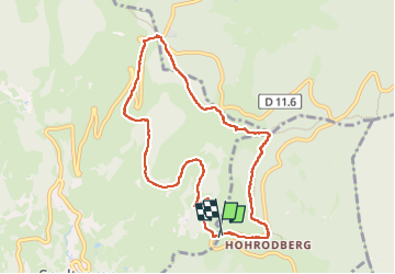

Length
8.7 km

Max alt
987 m

Uphill gradient
308 m
Km-Effort
12.8 km

Min alt
739 m

Downhill gradient
306 m
Boucle
Yes
Creation date :
2024-07-29 11:48:44.356
Updated on :
2024-08-31 14:24:23.829
3h32
Difficulty : Difficult

FREE GPS app for hiking
 SityTrail
IGN / Geographical institutes
SityTrail Plus
The world is yours!
About
Trail Walking of 8.7 km to be discovered at Grand Est, Haut-Rhin, Soultzeren. This trail is proposed by jcschubnel.
Positioning
Country:
France
Region :
Grand Est
Department/Province :
Haut-Rhin
Municipality :
Soultzeren
Location:
Unknown
Start:(Dec)
Start:(UTM)
360354 ; 5325443 (32U) N.
Comments