


Labaroche

jcschubnel
User
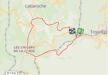

Length
8.2 km

Max alt
846 m

Uphill gradient
253 m
Km-Effort
11.5 km

Min alt
657 m

Downhill gradient
255 m
Boucle
Yes
Creation date :
2024-08-30 11:30:25.118
Updated on :
2024-08-31 14:24:26.329
2h59
Difficulty : Medium

FREE GPS app for hiking
 SityTrail
IGN / Geographical institutes
SityTrail Plus
The world is yours!
About
Trail Walking of 8.2 km to be discovered at Grand Est, Haut-Rhin, Labaroche. This trail is proposed by jcschubnel.
Positioning
Country:
France
Region :
Grand Est
Department/Province :
Haut-Rhin
Municipality :
Labaroche
Location:
Unknown
Start:(Dec)
Start:(UTM)
367290 ; 5328676 (32U) N.
Comments