


refuge enfants m

JPS73
User
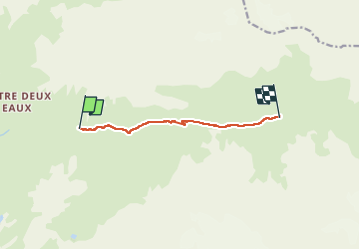

Length
6.4 km

Max alt
2369 m

Uphill gradient
244 m
Km-Effort
9 km

Min alt
2159 m

Downhill gradient
47 m
Boucle
No
Creation date :
2024-08-27 08:56:03.835
Updated on :
2024-09-01 14:35:17.406
2h03
Difficulty : Medium

FREE GPS app for hiking
 SityTrail
IGN / Geographical institutes
SityTrail Plus
The world is yours!
About
Trail Walking of 6.4 km to be discovered at Auvergne-Rhône-Alpes, Savoy, Val-Cenis. This trail is proposed by JPS73.
Positioning
Country:
France
Region :
Auvergne-Rhône-Alpes
Department/Province :
Savoy
Municipality :
Val-Cenis
Location:
Termignon
Start:(Dec)
Start:(UTM)
332404 ; 5025166 (32T) N.
Comments