


lac noir/lac Forlet

geoffrayLayeux
User
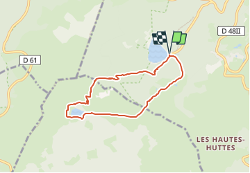

Length
6.2 km

Max alt
1272 m

Uphill gradient
389 m
Km-Effort
11.4 km

Min alt
952 m

Downhill gradient
389 m
Boucle
Yes
Creation date :
2024-09-06 20:36:24.654
Updated on :
2024-09-06 20:36:26.589
2h35
Difficulty : Medium

FREE GPS app for hiking
 SityTrail
IGN / Geographical institutes
SityTrail Plus
The world is yours!
About
Trail Walking of 6.2 km to be discovered at Grand Est, Haut-Rhin, Orbey. This trail is proposed by geoffrayLayeux.
Positioning
Country:
France
Region :
Grand Est
Department/Province :
Haut-Rhin
Municipality :
Orbey
Location:
Unknown
Start:(Dec)
Start:(UTM)
358577 ; 5330568 (32U) N.
Comments