


Ferrette/Altkirch

boubou68
User
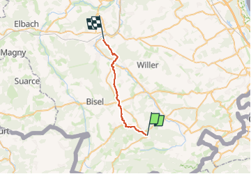

Length
20 km

Max alt
562 m

Uphill gradient
256 m
Km-Effort
24 km

Min alt
314 m

Downhill gradient
484 m
Boucle
No
Creation date :
2024-09-08 12:56:55.034
Updated on :
2024-09-08 12:56:56.652
5h33
Difficulty : Very difficult

FREE GPS app for hiking
 SityTrail
IGN / Geographical institutes
SityTrail Plus
The world is yours!
About
Trail Walking of 20 km to be discovered at Grand Est, Haut-Rhin, Ferrette. This trail is proposed by boubou68.
Description
Un retour sur Altkich après une arrivée sur Ferrette..[ projet ]
Positioning
Country:
France
Region :
Grand Est
Department/Province :
Haut-Rhin
Municipality :
Ferrette
Location:
Unknown
Start:(Dec)
Start:(UTM)
373450 ; 5261246 (32T) N.
Comments