


De hameaux en hameaux autour de Courchevel

Chabard
User
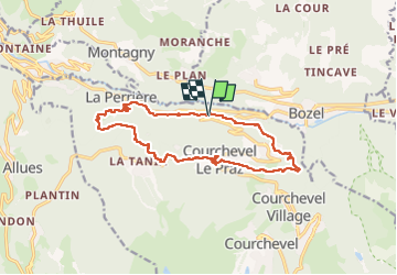

Length
16.2 km

Max alt
1351 m

Uphill gradient
719 m
Km-Effort
26 km

Min alt
763 m

Downhill gradient
714 m
Boucle
Yes
Creation date :
2024-09-09 08:23:51.0
Updated on :
2024-09-15 18:01:53.993
6h19
Difficulty : Medium

FREE GPS app for hiking
 SityTrail
IGN / Geographical institutes
SityTrail Plus
The world is yours!
About
Trail Walking of 16.2 km to be discovered at Auvergne-Rhône-Alpes, Savoy, Courchevel. This trail is proposed by Chabard.
Description
La Perrière - Villanard - Villaflou - Le Tal - Courchevel Le Praz - La Jairaz - Saint Bon - Le Fay
Positioning
Country:
France
Region :
Auvergne-Rhône-Alpes
Department/Province :
Savoy
Municipality :
Courchevel
Location:
Saint-Bon-Tarentaise
Start:(Dec)
Start:(UTM)
313736 ; 5034822 (32T) N.
Comments