


Hameaux autour de Villemartin (au-dessus de Bozel)

Chabard
User

Length
9.1 km

Max alt
1619 m

Uphill gradient
506 m
Km-Effort
15.9 km

Min alt
1108 m

Downhill gradient
504 m
Boucle
Yes
Creation date :
2024-09-12 08:08:41.0
Updated on :
2024-09-15 17:42:20.357
3h16
Difficulty : Easy

FREE GPS app for hiking
 SityTrail
IGN / Geographical institutes
SityTrail Plus
The world is yours!
About
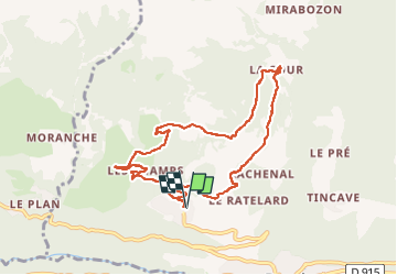
Trail Walking of 9.1 km to be discovered at Auvergne-Rhône-Alpes, Savoy, Bozel. This trail is proposed by Chabard.
Description
Villemartin - Les Champs - La Cour - Lachenal - Villemartin
Positioning
Country:
France
Region :
Auvergne-Rhône-Alpes
Department/Province :
Savoy
Municipality :
Bozel
Location:
Unknown
Start:(Dec)
Start:(UTM)
314966 ; 5035736 (32T) N.
Comments