Trail Walking Ferrières - RF-Lg-05_My - Photo

Randonnez sur et autour des GR ® wallons (Sentiers de Grande Randonnée). PRO

© OpenStreetMap contributors
Length
Length
11.2 km
Max alt
Max alt
266 m
Uphill gradient
Uphill gradient
252 m
Km-Effort
Km-Effort  
14.6 km
Min alt
Min alt
144 m
Downhill gradient
Downhill gradient
252 m
Boucle
Boucle
Yes
Creation date :
2019-08-07 07:21:45.587
Updated on :
2022-05-07 11:11:38.378

(0 Reviews)

Walking
Walking
2h06
Difficulty : Unknown

Scan this QR Code to open this trail in the SityTrail application

FREE GPS app for hiking

Logo SityTrail SityTrail

IGN / Geographical institutes

Download SityTrail from the App Store Download SityTrail from Google Play

Logo SityTrail SityTrail World

The world is yours!

Download SityTrail from the App Store Download SityTrail from Google Play Download SityTrail on Huawei AppGallery

About

Trail Walking of 11.2 km to be discovered at Wallonia, Liège, Ferrières. This trail is proposed by GR Rando.

Description

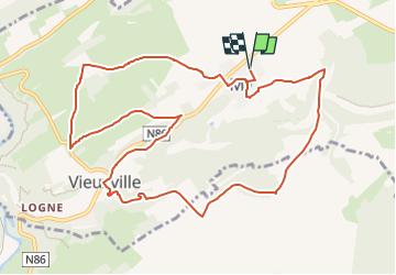
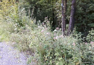
RF-LG-05 - Raccourci 1&2 - En surplombant les rochers de l'Ourthe à Sy : My

Remarques importante: Cette randonnée est à déconseiller en cas de situation de crue des rivières de la région ! Vous auriez des problèmes pour franchir le gué sur la Lembrée au point repère (1)

Dans quel type de paysage randonnons-nous?
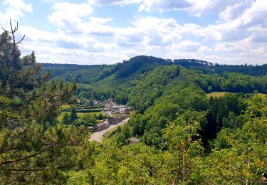
L’itinéraire de cette rando pénètre d’abord dans la vallée de la Lembrée puis rejoint la crête surplombant l’Ourthe, enfin s’en va musarder à travers champs sur un des sommets de la Famenne.

Quelle difficulté ?
Aucune.

Combien de kilomètres ?
7,5 km

Sur quels GR randonnons-nous ?
Sur le GR 57 «Vallée de l’Ourthe et Sentier du Nord» et le GR 576 «Tour du Condroz liégeois ».

Où démarrons-nous ?
À l’église de My (carte Michelin n° 534, pli S/20).

Comment y arriver ?
Le très beau village de My est situé sur la N86, Aywaille – Bomal – Barvaux – Hotton – Marche-en-Famenne.

Que découvrons-nous aujourd’hui ?
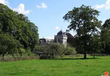
Au musée de la ferme de la Bouverie, nous pourrons approcher la façon dont les gens vivaient au moyen âge. Après une visite des ruines du château fort de Logne, nous pourrons assister à un spectacle de fauconnerie. Un peu de kayak à la ferme de Palogne pourrait conclure la journée.

Quelle est la carte IGN de référence ?
Carte IGN au 1 : 20 000 : «Hamoir – Ferrières», 49/5-6.

Transports en commun?
Aucun.

Points of interest

Point of interest Ferrières - Camps des Hussards - Photo
GR Rando
FERRIÈRES 
Point of interest Ferrières - My - Photo
grsentiers
FERRIÈRES 
Point of interest Ferrières - Sol Paradis - Photo
grsentiers
FERRIÈRES 
Point of interest Ferrières - Rés. for. de la Grande Vâ - Photo
grsentiers
Point of interest Ferrières - Cimetière de Vieuxville - Photo
grsentiers
Point of interest Ferrières - Esplanade Lieutenant Patrick - Photo
grsentiers
Point of interest Ferrières - Tchafor - Photo
grsentiers
FERRIÈRES 

Positioning

Country:
Belgium
Region :
Wallonia
Department/Province :
Liège
Municipality :
Ferrières
Location:
Unknown
Start:(UTM)
682898 ; 5587021 (31U) N.

Comments

Please log in to post a review or rate the element


Belle promenade avec des chemins bien tranquilles


Trails nearby

Trail Walking Hamoir - RB-Lg-19_Hamoir - Photo
Walking
PRO

Walking

Very difficult
(6)
Hamoir, Wallonia, Liège, Belgium
22 km | 28 km-effort
6h 18min
Yes
Trail Walking Ferrières - Rouge-Minière. Natura 2000, des sites qui valent le détour ! Lg 3 - Photo
Walking
GUIDE+

Walking

Easy
(17)
Ferrières, Wallonia, Liège, Belgium
6.8 km | 8.9 km-effort
Unknown
Yes
Trail Walking Durbuy - Balade à Bomal sur Ourthe - Photo
Walking
GUIDE
Desrumaux

Walking

Easy
(1)
Durbuy, Wallonia, Luxembourg, Belgium
4.4 km | 5.9 km-effort
1h 20min
Yes
Trail Walking Ferrières - GG-Lu-15_Sy - Barvaux - Photo
Walking
PRO

Walking

Very difficult
(1)
Ferrières, Wallonia, Liège, Belgium
18.9 km | 26 km-effort
5h 58min
No
Trail Walking Durbuy - GG2-Lu-36_Bomal-Marloie (2021-11-04) - Photo
Walking
PRO

Walking

Medium
(2)
Durbuy, Wallonia, Luxembourg, Belgium
43 km | 52 km-effort
11h 51min
No
Trail Mountain bike Ferrières - st-roch - Photo
Mountain bike
exogarix

Mountain bike

Medium
(1)
Ferrières, Wallonia, Liège, Belgium
11.9 km | 14.9 km-effort
1h 45min
Yes
Trail Walking Ferrières - en passant par la chapelle Saint Roch  - Photo
Walking
naturaliste

Walking

Easy
(2)
Ferrières, Wallonia, Liège, Belgium
4.8 km | 5.9 km-effort
58min
Yes
Trail Walking Hamoir - RB-Lg-19_Hamoir_via-racc-2 - Photo
Walking
PRO

Walking

Very difficult
(4)
Hamoir, Wallonia, Liège, Belgium
16 km | 20 km-effort
4h 36min
Yes
Trail Walking Hamoir - RB-Lg-19_Hamoir_via-racc-1 - Photo
Walking
PRO

Walking

Difficult
(2)
Hamoir, Wallonia, Liège, Belgium
11.4 km | 15.1 km-effort
3h 26min
Yes


Close
My subscriptions