


Ger RS LAC de Ponson

LouisROGER
User GUIDE
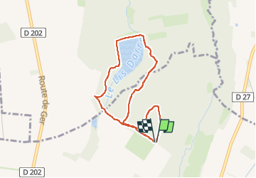

Length
3.7 km

Max alt
395 m

Uphill gradient
34 m
Km-Effort
4.2 km

Min alt
367 m

Downhill gradient
35 m
Boucle
Yes
Creation date :
2024-09-17 11:57:26.602
Updated on :
2024-09-19 19:50:34.587
2h22
Difficulty : Easy

FREE GPS app for hiking
 SityTrail
IGN / Geographical institutes
SityTrail Plus
The world is yours!
About
Trail Walking of 3.7 km to be discovered at New Aquitaine, Pyrénées-Atlantiques, Ger. This trail is proposed by LouisROGER.
Positioning
Country:
France
Region :
New Aquitaine
Department/Province :
Pyrénées-Atlantiques
Municipality :
Ger
Location:
Unknown
Start:(Dec)
Start:(UTM)
739243 ; 4796301 (30T) N.
Comments