


Col Saint Antoine

orsel
User GUIDE
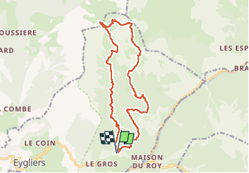

Length
18.8 km

Max alt
2457 m

Uphill gradient
1290 m
Km-Effort
36 km

Min alt
1426 m

Downhill gradient
1295 m
Boucle
Yes
Creation date :
2024-09-20 06:41:59.468
Updated on :
2024-09-20 16:07:50.771
7h23
Difficulty : Difficult

FREE GPS app for hiking
 SityTrail
IGN / Geographical institutes
SityTrail Plus
The world is yours!
About
Trail Walking of 18.8 km to be discovered at Provence-Alpes-Côte d'Azur, Hautes-Alpes, Eygliers. This trail is proposed by orsel.
Positioning
Country:
France
Region :
Provence-Alpes-Côte d'Azur
Department/Province :
Hautes-Alpes
Municipality :
Eygliers
Location:
Unknown
Start:(Dec)
Start:(UTM)
315970 ; 4949983 (32T) N.
Comments