


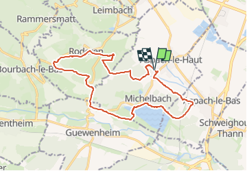
Aspach le haut

Alain28/01
User

Length
16.5 km

Max alt
473 m

Uphill gradient
336 m
Km-Effort
21 km

Min alt
298 m

Downhill gradient
339 m
Boucle
Yes
Creation date :
2024-09-23 11:54:43.989
Updated on :
2024-09-23 11:55:38.204
4h46
Difficulty : Easy

FREE GPS app for hiking
 SityTrail
IGN / Geographical institutes
SityTrail Plus
The world is yours!
About
Trail Walking of 16.5 km to be discovered at Grand Est, Haut-Rhin, Aspach-Michelbach. This trail is proposed by Alain28/01.
Positioning
Country:
France
Region :
Grand Est
Department/Province :
Haut-Rhin
Municipality :
Aspach-Michelbach
Location:
Aspach-le-Haut
Start:(Dec)
Start:(UTM)
359483 ; 5292789 (32T) N.
Comments