


la-crete-du-loup

clintest
User
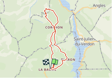

Length
15.4 km

Max alt
1411 m

Uphill gradient
695 m
Km-Effort
25 km

Min alt
1047 m

Downhill gradient
704 m
Boucle
Yes
Creation date :
2024-09-27 14:18:29.389
Updated on :
2024-09-27 14:18:29.389

FREE GPS app for hiking
 SityTrail
IGN / Geographical institutes
SityTrail Plus
The world is yours!
About
Trail of 15.4 km to be discovered at Provence-Alpes-Côte d'Azur, Alpes-de-Haute-Provence, Castellane. This trail is proposed by clintest.
Description
autre calcul de la balade la baume
Positioning
Country:
France
Region :
Provence-Alpes-Côte d'Azur
Department/Province :
Alpes-de-Haute-Provence
Municipality :
Castellane
Location:
Unknown
Start:(Dec)
Start:(UTM)
299568 ; 4862957 (32T) N.
Comments