


vosges 2024 J1

Airelle
User
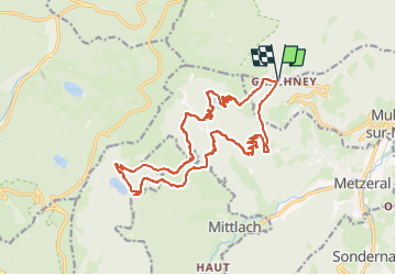

Length
19.4 km

Max alt
1174 m

Uphill gradient
928 m
Km-Effort
32 km

Min alt
709 m

Downhill gradient
919 m
Boucle
Yes
Creation date :
2024-09-28 18:05:48.998
Updated on :
2024-09-28 18:26:17.138
7h13
Difficulty : Very difficult

FREE GPS app for hiking
 SityTrail
IGN / Geographical institutes
SityTrail Plus
The world is yours!
About
Trail Walking of 19.4 km to be discovered at Grand Est, Haut-Rhin, Muhlbach-sur-Munster. This trail is proposed by Airelle.
Positioning
Country:
France
Region :
Grand Est
Department/Province :
Haut-Rhin
Municipality :
Muhlbach-sur-Munster
Location:
Unknown
Start:(Dec)
Start:(UTM)
354245 ; 5321947 (32U) N.
Comments