Trail Other activity Bastelica - Bastelica chutes Ortola AR - Photo

Bastelica chutes Ortola AR

 diby
diby

User

© OpenStreetMap contributors
Length
Length
6.3 km
Max alt
Max alt
1136 m
Uphill gradient
Uphill gradient
339 m
Km-Effort
Km-Effort  
10.8 km
Min alt
Min alt
840 m
Downhill gradient
Downhill gradient
336 m
Boucle
Boucle
Yes
Creation date :
2015-05-14 00:00:00.0
Updated on :
2015-05-14 00:00:00.0

(0 Reviews)

Other activity
Other activity
3h44
Difficulty : Easy

Scan this QR Code to open this trail in the SityTrail application

FREE GPS app for hiking

Logo SityTrail SityTrail

IGN / Geographical institutes

Download SityTrail from the App Store Download SityTrail from Google Play

Logo SityTrail SityTrail World

The world is yours!

Download SityTrail from the App Store Download SityTrail from Google Play Download SityTrail on Huawei AppGallery

About

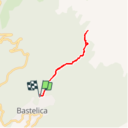
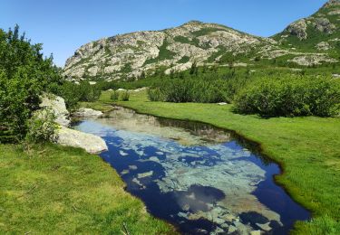
Trail Other activity of 6.3 km to be discovered at Corsica, South Corsica, Bastelica. This trail is proposed by diby.

Description

balade familiale montée difficile au début puis parcours ombragé pratiquement plat

Elevation profile

Positioning

Country:
France
Region :
Corsica
Department/Province :
South Corsica
Municipality :
Bastelica
Location:
Unknown
Start:(UTM)
504334 ; 4650349 (32T) N.

Trails nearby

Trail Walking Bastelica - piscia d'Ortola - Photo
Walking
GUIDE
nadinebondoux

Walking

Medium
Bastelica, Corsica, South Corsica, France
6.1 km | 10.5 km-effort
2h 32min
Yes
Trail Walking Bastelica - Randoguide - Photo
Walking
Tukeke

Walking

Medium
(1)
Bastelica, Corsica, South Corsica, France
19.8 km | 34 km-effort
6h 47min
Yes
Trail Walking Bastelica - aFurestaDiZipituli - Photo
Walking
daisychain

Walking

Very easy
Bastelica, Corsica, South Corsica, France
6.8 km | 9.2 km-effort
1h 47min
Yes
Trail Walking Bastelica - Bastelica Camping Bastelica  - Photo
Walking
tonio2A

Walking

Medium
Bastelica, Corsica, South Corsica, France
4.8 km | 8 km-effort
1h 26min
Yes
Trail Walking Bastelica - Bastelica - Photo
Walking
Indi34

Walking

Medium
Bastelica, Corsica, South Corsica, France
11.6 km | 17.8 km-effort
5h 22min
Yes
Trail Walking Tavera - Pozzines de Pozzolo - Photo
Walking
christian pradel2

Walking

Easy
Tavera, Corsica, South Corsica, France
15.9 km | 25 km-effort
7h 34min
Yes
Trail Walking Bastelica - Lac de VITALACA - Photo
Walking
cathymac20

Walking

Very difficult
Bastelica, Corsica, South Corsica, France
17.9 km | 31 km-effort
6h 20min
Yes
Trail Walking Tavera - Punta Piaggiola  et Monte Niello depuis Scallela - Photo
Walking
christian pradel2

Walking

Very difficult
Tavera, Corsica, South Corsica, France
17.5 km | 32 km-effort
7h 9min
Yes
Trail sport Tavera - 2021-05-20_17h58m13_SityTrail - 2793375 - sfronditata-par-porcilleli - Photo
sport
accelascien

sport

Very easy
Tavera, Corsica, South Corsica, France
16.6 km | 29 km-effort
Unknown
Yes


Close
My subscriptions