


Bourbach le bas

Alain28/01
User
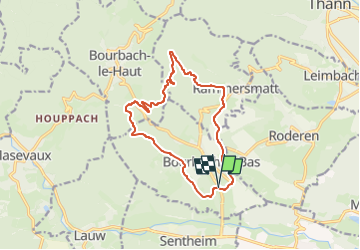

Length
13.1 km

Max alt
672 m

Uphill gradient
495 m
Km-Effort
19.7 km

Min alt
356 m

Downhill gradient
496 m
Boucle
Yes
Creation date :
2024-09-30 14:16:40.814
Updated on :
2024-09-30 14:17:14.98
4h28
Difficulty : Very difficult

FREE GPS app for hiking
 SityTrail
IGN / Geographical institutes
SityTrail Plus
The world is yours!
About
Trail Walking of 13.1 km to be discovered at Grand Est, Haut-Rhin, Bourbach-le-Bas. This trail is proposed by Alain28/01.
Positioning
Country:
France
Region :
Grand Est
Department/Province :
Haut-Rhin
Municipality :
Bourbach-le-Bas
Location:
Unknown
Start:(Dec)
Start:(UTM)
354938 ; 5292279 (32T) N.
Comments