Reiningue

Alain28/01
User
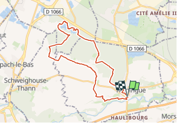

Length
16.7 km

Max alt
297 m

Uphill gradient
119 m
Km-Effort
18.3 km

Min alt
259 m

Downhill gradient
118 m
Boucle
Yes
Creation date :
2024-09-30 14:31:34.787
Updated on :
2024-09-30 14:32:19.739
4h09
Difficulty : Easy

FREE GPS app for hiking
 SityTrail
IGN / Geographical institutes
SityTrail Plus
The world is yours!
About
Trail Walking of 16.7 km to be discovered at Grand Est, Haut-Rhin, Reiningue. This trail is proposed by Alain28/01.
Positioning
Country:
France
Region :
Grand Est
Department/Province :
Haut-Rhin
Municipality :
Reiningue
Location:
Unknown
Start:(Dec)
Start:(UTM)
367569 ; 5289760 (32T) N.
Comments