


Tour cahors par GR65

jvignaud
User
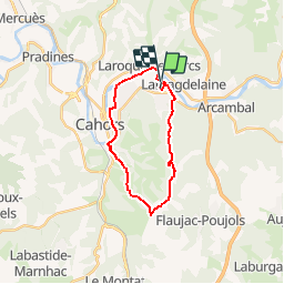

Length
20 km

Max alt
293 m

Uphill gradient
297 m
Km-Effort
24 km

Min alt
114 m

Downhill gradient
325 m
Boucle
No
Creation date :
2014-12-10 00:00:00.0
Updated on :
2014-12-10 00:00:00.0
5h37
Difficulty : Unknown

FREE GPS app for hiking
 SityTrail
IGN / Geographical institutes
SityTrail Plus
The world is yours!
About
Trail Walking of 20 km to be discovered at Occitania, Lot, Cahors. This trail is proposed by jvignaud.
Positioning
Country:
France
Region :
Occitania
Department/Province :
Lot
Municipality :
Cahors
Location:
Unknown
Start:(Dec)
Start:(UTM)
378645 ; 4924683 (31T) N.
Comments
mont est cyr
ville superbe