


73V Les Trois Croix

trietsch
User
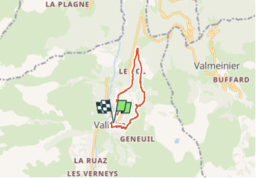

Length
8.5 km

Max alt
1753 m

Uphill gradient
417 m
Km-Effort
14.1 km

Min alt
1393 m

Downhill gradient
416 m
Boucle
Yes
Creation date :
2015-05-15 00:00:00.0
Updated on :
2024-09-07 12:19:29.444
3h11
Difficulty : Difficult

FREE GPS app for hiking
 SityTrail
IGN / Geographical institutes
SityTrail Plus
The world is yours!
About
Trail Walking of 8.5 km to be discovered at Auvergne-Rhône-Alpes, Savoy, Valloire. This trail is proposed by trietsch.
Description
et raquettes
Positioning
Country:
France
Region :
Auvergne-Rhône-Alpes
Department/Province :
Savoy
Municipality :
Valloire
Location:
Unknown
Start:(Dec)
Start:(UTM)
298105 ; 5004602 (32T) N.
Comments