


RIF-09-5-du 27.09.2024

bene_dictus77
User
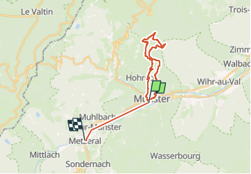

Length
24 km

Max alt
1049 m

Uphill gradient
858 m
Km-Effort
35 km

Min alt
375 m

Downhill gradient
764 m
Boucle
No
Creation date :
2024-09-27 07:22:07.139
Updated on :
2024-10-02 11:42:35.939
8h00
Difficulty : Medium

FREE GPS app for hiking
 SityTrail
IGN / Geographical institutes
SityTrail Plus
The world is yours!
About
Trail Walking of 24 km to be discovered at Grand Est, Haut-Rhin, Munster. This trail is proposed by bene_dictus77.
Description
de Munster au Linge
Positioning
Country:
France
Region :
Grand Est
Department/Province :
Haut-Rhin
Municipality :
Munster
Location:
Unknown
Start:(Dec)
Start:(UTM)
360922 ; 5322245 (32U) N.
Comments