


chateaujulien

Liebeaux
User
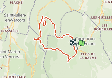

Length
17.9 km

Max alt
1554 m

Uphill gradient
716 m
Km-Effort
27 km

Min alt
1138 m

Downhill gradient
720 m
Boucle
Yes
Creation date :
2024-10-03 06:45:21.596
Updated on :
2024-10-03 13:53:17.567
7h06
Difficulty : Very difficult

FREE GPS app for hiking
 SityTrail
IGN / Geographical institutes
SityTrail Plus
The world is yours!
About
Trail Walking of 17.9 km to be discovered at Auvergne-Rhône-Alpes, Isère, Corrençon-en-Vercors. This trail is proposed by Liebeaux.
Positioning
Country:
France
Region :
Auvergne-Rhône-Alpes
Department/Province :
Isère
Municipality :
Corrençon-en-Vercors
Location:
Unknown
Start:(Dec)
Start:(UTM)
698374 ; 4988788 (31T) N.
Comments