


Reinîn gue- copain- plat-2/10/24

chantalwaltzer
User
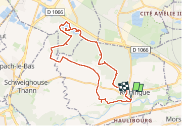

Length
19 km

Max alt
297 m

Uphill gradient
143 m
Km-Effort
21 km

Min alt
259 m

Downhill gradient
143 m
Boucle
Yes
Creation date :
2024-10-03 06:56:08.0
Updated on :
2024-10-03 18:59:32.407
6h44
Difficulty : Unknown

FREE GPS app for hiking
 SityTrail
IGN / Geographical institutes
SityTrail Plus
The world is yours!
About
Trail Walking of 19 km to be discovered at Grand Est, Haut-Rhin, Reiningue. This trail is proposed by chantalwaltzer.
Description
bien
Positioning
Country:
France
Region :
Grand Est
Department/Province :
Haut-Rhin
Municipality :
Reiningue
Location:
Unknown
Start:(Dec)
Start:(UTM)
367548 ; 5289808 (32T) N.
Comments