


PLATZERWASEL COL SCHNEPFENRIED

surceneux
User
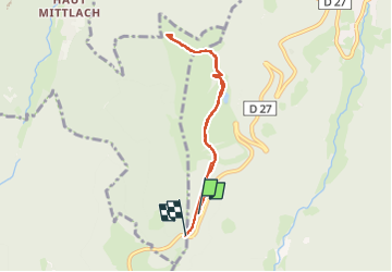

Length
6.1 km

Max alt
1194 m

Uphill gradient
171 m
Km-Effort
8.3 km

Min alt
1040 m

Downhill gradient
148 m
Boucle
No
Creation date :
2024-10-06 13:41:23.843
Updated on :
2024-10-06 17:33:16.624
1h20
Difficulty : Easy

FREE GPS app for hiking
 SityTrail
IGN / Geographical institutes
SityTrail Plus
The world is yours!
About
Trail Walking of 6.1 km to be discovered at Grand Est, Haut-Rhin, Sondernach. This trail is proposed by surceneux.
Description
PLATZERWASEL COL SCHNEPFENRIED AR PAR DISQUE BLEU
Positioning
Country:
France
Region :
Grand Est
Department/Province :
Haut-Rhin
Municipality :
Sondernach
Location:
Unknown
Start:(Dec)
Start:(UTM)
354080 ; 5315029 (32T) N.
Comments