


Bayons Reynier 10 octobre 2024

rlebasque
User
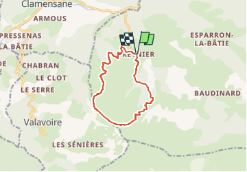

Length
11.4 km

Max alt
1782 m

Uphill gradient
846 m
Km-Effort
23 km

Min alt
932 m

Downhill gradient
847 m
Boucle
Yes
Creation date :
2024-10-09 07:17:56.118
Updated on :
2024-10-09 12:27:04.345
5h08
Difficulty : Very difficult

FREE GPS app for hiking
 SityTrail
IGN / Geographical institutes
SityTrail Plus
The world is yours!
About
Trail Walking of 11.4 km to be discovered at Provence-Alpes-Côte d'Azur, Alpes-de-Haute-Provence, Bayons. This trail is proposed by rlebasque.
Positioning
Country:
France
Region :
Provence-Alpes-Côte d'Azur
Department/Province :
Alpes-de-Haute-Provence
Municipality :
Bayons
Location:
Reynier
Start:(Dec)
Start:(UTM)
269778 ; 4909639 (32T) N.
Comments