


rando urbeis

chantalwaltzer
User
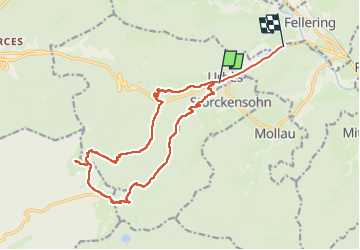

Length
16.8 km

Max alt
1118 m

Uphill gradient
823 m
Km-Effort
28 km

Min alt
445 m

Downhill gradient
822 m
Boucle
No
Creation date :
2024-10-10 07:38:26.0
Updated on :
2024-10-10 14:14:01.216
6h34
Difficulty : Unknown

FREE GPS app for hiking
 SityTrail
IGN / Geographical institutes
SityTrail Plus
The world is yours!
About
Trail Walking of 16.8 km to be discovered at Grand Est, Haut-Rhin, Urbès. This trail is proposed by chantalwaltzer.
Description
bie
Positioning
Country:
France
Region :
Grand Est
Department/Province :
Haut-Rhin
Municipality :
Urbès
Location:
Unknown
Start:(Dec)
Start:(UTM)
347083 ; 5305252 (32T) N.
Comments