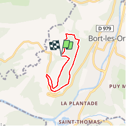
Trail Walking Bort-les-Orgues - Bort-les-Orgues - Photo
 houbart
houbart

User

© OpenStreetMap contributors
Length
Length
5 km
Max alt
Max alt
793 m
Uphill gradient
Uphill gradient
170 m
Km-Effort
Km-Effort  
7.2 km
Min alt
Min alt
642 m
Downhill gradient
Downhill gradient
163 m
Boucle
Boucle
Yes
Creation date :
2019-03-28 15:47:31.634
Updated on :
2019-03-28 15:47:31.699

(0 Reviews)

Walking
Walking
1h37
Difficulty : Medium

Scan this QR Code to open this trail in the SityTrail application

FREE GPS app for hiking

Logo SityTrail SityTrail

IGN / Geographical institutes

Download SityTrail from the App Store Download SityTrail from Google Play

Logo SityTrail SityTrail Plus

The world is yours!

Download SityTrail from the App Store Download SityTrail from Google Play Download SityTrail on Huawei AppGallery

About

Trail Walking of 5 km to be discovered at New Aquitaine, Corrèze, Bort-les-Orgues. This trail is proposed by houbart.

Description

Départ aire de stationnement pour l'accès aux belvédères des orgues. Traversée d'une hêtraie chênaie, puis la corniche de sorgues (points de vue sur Bort les Orgues et sa vallée, les monts d'Auvergne et la plaine de Madic.

Elevation profile

Photos

Points of interest

Point of interest Bort-les-Orgues - Vue sur les Monts d'Auvergne - Photo
houbart
Point of interest Bort-les-Orgues - Les orgues - Photo
houbart
BORT-LES-ORGUES 

Positioning

Country:
France
Region :
New Aquitaine
Department/Province :
Corrèze
Municipality :
Bort-les-Orgues
Location:
Unknown
Start:(UTM)
459340 ; 5027144 (31T) N.

Comments

Please log in to post a review or rate the element


Close
My subscriptions