


Aiguebelette 1

gallo
User

Length
11.7 km

Max alt
965 m

Uphill gradient
562 m
Km-Effort
19.3 km

Min alt
417 m

Downhill gradient
566 m
Boucle
Yes
Creation date :
2015-05-20 00:00:00.0
Updated on :
2015-05-20 00:00:00.0
4h10
Difficulty : Medium

FREE GPS app for hiking
 SityTrail
IGN / Geographical institutes
SityTrail Plus
The world is yours!
About
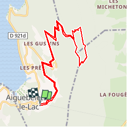
Trail Walking of 11.7 km to be discovered at Auvergne-Rhône-Alpes, Savoy, Aiguebelette-le-Lac. This trail is proposed by gallo.
Positioning
Country:
France
Region :
Auvergne-Rhône-Alpes
Department/Province :
Savoy
Municipality :
Aiguebelette-le-Lac
Location:
Unknown
Start:(Dec)
Start:(UTM)
719955 ; 5046463 (31T) N.
Comments