


Wettolsheim

Alain28/01
User
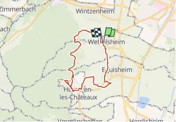

Length
14.1 km

Max alt
584 m

Uphill gradient
492 m
Km-Effort
21 km

Min alt
213 m

Downhill gradient
492 m
Boucle
Yes
Creation date :
2024-10-21 19:57:36.044
Updated on :
2024-10-21 19:58:20.699
4h41
Difficulty : Medium

FREE GPS app for hiking
 SityTrail
IGN / Geographical institutes
SityTrail Plus
The world is yours!
About
Trail Walking of 14.1 km to be discovered at Grand Est, Haut-Rhin, Wettolsheim. This trail is proposed by Alain28/01.
Positioning
Country:
France
Region :
Grand Est
Department/Province :
Haut-Rhin
Municipality :
Wettolsheim
Location:
Unknown
Start:(Dec)
Start:(UTM)
373192 ; 5324072 (32U) N.
Comments