


col de guisergue

gilder89
User
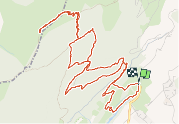

Length
9.9 km

Max alt
1729 m

Uphill gradient
684 m
Km-Effort
19 km

Min alt
1051 m

Downhill gradient
681 m
Boucle
Yes
Creation date :
2024-10-29 10:20:44.532
Updated on :
2024-10-29 15:19:47.383
4h33
Difficulty : Medium

FREE GPS app for hiking
 SityTrail
IGN / Geographical institutes
SityTrail Plus
The world is yours!
About
Trail Walking of 9.9 km to be discovered at Provence-Alpes-Côte d'Azur, Hautes-Alpes, Gap. This trail is proposed by gilder89.
Description
Randonnée en familiale avec un challenge de dénivelé tout de même.
Positioning
Country:
France
Region :
Provence-Alpes-Côte d'Azur
Department/Province :
Hautes-Alpes
Municipality :
Gap
Location:
Gap
Start:(Dec)
Start:(UTM)
266544 ; 4940792 (32T) N.
Comments