


Montagne de Sous Dîne

Chabard
User
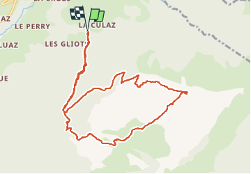

Length
11.4 km

Max alt
1993 m

Uphill gradient
912 m
Km-Effort
24 km

Min alt
1088 m

Downhill gradient
915 m
Boucle
Yes
Creation date :
2024-10-29 08:47:59.0
Updated on :
2024-10-29 19:24:57.227
5h22
Difficulty : Very difficult

FREE GPS app for hiking
 SityTrail
IGN / Geographical institutes
SityTrail Plus
The world is yours!
About
Trail Walking of 11.4 km to be discovered at Auvergne-Rhône-Alpes, Upper Savoy, Fillière. This trail is proposed by Chabard.
Description
Les Cheneviers - Les Avoinières - Combe Arembeau - Passage de Monthieu - Sous-Dîne - Trou de la Pierre - Col de l'Enclave - Chalet de l'Artu - Les Cheneviers
Positioning
Country:
France
Region :
Auvergne-Rhône-Alpes
Department/Province :
Upper Savoy
Municipality :
Fillière
Location:
Thorens-Glières
Start:(Dec)
Start:(UTM)
291076 ; 5099203 (32T) N.
Comments