


bivouac

luky0007
User
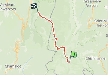

Length
15.1 km

Max alt
1730 m

Uphill gradient
208 m
Km-Effort
18.7 km

Min alt
1359 m

Downhill gradient
464 m
Boucle
No
Creation date :
2024-10-13 08:10:38.776
Updated on :
2024-10-30 19:33:47.808
4h37
Difficulty : Difficult

FREE GPS app for hiking
 SityTrail
IGN / Geographical institutes
SityTrail Plus
The world is yours!
About
Trail Walking of 15.1 km to be discovered at Auvergne-Rhône-Alpes, Isère, Chichilianne. This trail is proposed by luky0007.
Positioning
Country:
France
Region :
Auvergne-Rhône-Alpes
Department/Province :
Isère
Municipality :
Chichilianne
Location:
Unknown
Start:(Dec)
Start:(UTM)
698824 ; 4964589 (31T) N.
Comments