


SAPENAY - LES GRANGES - CROIX DU CLERGEON... retour par le pas de l'âne

djeepee74
User
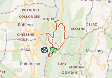

Length
11 km

Max alt
1025 m

Uphill gradient
397 m
Km-Effort
16.3 km

Min alt
755 m

Downhill gradient
397 m
Boucle
Yes
Creation date :
2024-11-04 08:06:43.078
Updated on :
2024-11-04 16:19:26.043
3h41
Difficulty : Difficult

FREE GPS app for hiking
 SityTrail
IGN / Geographical institutes
SityTrail Plus
The world is yours!
About
Trail Walking of 11 km to be discovered at Auvergne-Rhône-Alpes, Savoy, Entrelacs. This trail is proposed by djeepee74.
Description
BOUCLE... live du 20241104
Positioning
Country:
France
Region :
Auvergne-Rhône-Alpes
Department/Province :
Savoy
Municipality :
Entrelacs
Location:
Cessens
Start:(Dec)
Start:(UTM)
722856 ; 5078533 (31T) N.
Comments